Traveling through Time on Indiana’s Historic Pathways
Travel Indiana’s Historic Pathways, US 50/150, through the counties of Jackson, Lawrence, and Martin for some outdoor recreational fun. Each county offers its own unique way to explore the ruggedness of the land without going far from civilization.
| Departure: | Falls of the Ohio, Indiana |
|---|---|
| Destination: | Vincennes State Historic Site, Indiana |
| Time to allow: | 2 days |
Begin your experience of the byway at the very place where early pioneers would have disembarked from a boat on their journey from the Ohio River into the Indiana Territories.
Day 1
Start: Falls of the Ohio
Make your starting point the Falls of Ohio State Park and Interpretive Center, which is built on the site of the historic Falls of the Ohio River. Imagine the many historical travelers who disembarked from boats at this point to enter the Indiana frontier.
As the shallowest point in the Ohio River for miles, this spot also marks the place where buffalo forded the river, migrating from the blue grass in Kentucky across the Buffalo Trace to the plains of Illinois.
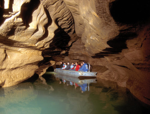
While you are at the Falls of the Ohio, check out the 386-million-year-old fossils, embedded in the largest naturally exposed Devonian fossil beds in the world. The park features a spectacular interpretive center overlooking the fossil beds, an exhibit gallery, and a video presentation. If you have some extra time, fishing, hiking, fossil-viewing, bird-watching, and picnicking are more popular activities you just might want to participate in.
Stop 1: George Rogers Clark Cabin Homesite, Clarksville, IN
| Directions from previous place: | Part of the Falls of the Ohio State Park, the George Rogers Clark Cabin Homesite is well-marked and just west of the interpretive center on a high bluff.
From the Interpretive Center at the Falls of the Ohio State Park, go southeast on Riverside Drive for 0.1 miles to Winbourne Avenue. Turn left and go north on Winbourne Avenue over the dike and then east for 0.4 miles to South Clark Boulevard. Turn left and go northwest on South Clark Boulevard for 0.85 miles to West Harrison Street. Turn left and go west on West Harrison Street west for 0.65 miles to the parking lot for the George Rogers Clark Homesite on the left. Park in the lot and walk east toward the homesite to the historical marker at the east end of the parking lot and the disk. |
|---|---|
| Distance from Previous Site: | 1 miles / 1.6 km |
| Travel Time from Previous Site: | 5 minutes |
| Suggested Time at This Site: | 30 minutes |
Find yourself at the very site marking the departure of the Lewis and Clark expedition in 1803. The cabin homesite is a reproduction of the home built by General George Rogers Clark. Prior to this point, Lewis and his men traveled downriver to meet up with William Clark (George Roger Clark’s younger brother) for their grand explorations of the Louisiana Purchase Territory.
Stop 2: Howard Steamboat Museum, Jeffersonville, IN
| Directions from Previous Site: | 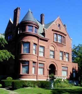 Once you’ve explored the cabin homesite, go back past the Falls of the Ohio State Park and take W. Riverside Drive toward West Winbourne Avenue. Turn left onto Southern Indiana Avenue. Turn right onto West Market Street and continue to 1101 E. Market St. Once you’ve explored the cabin homesite, go back past the Falls of the Ohio State Park and take W. Riverside Drive toward West Winbourne Avenue. Turn left onto Southern Indiana Avenue. Turn right onto West Market Street and continue to 1101 E. Market St. |
|---|---|
| Distance from Previous Site: | 4 miles / 6.4 km |
| Travel Time from Previous Site: | 7 minutes |
| Suggested Time at This Site: | 1 hour 30 minutes |
At the Howard Steamboat Museum, you’ll learn all about the Howard family, who built the steamboats in the late 1800s that plied the Ohio River. This home-turned-museum was built by those same craftsmen that worked in their shipyards. As you peruse the exquisite 22-room, late-Victorian mansion, gain an appreciation and an understanding of the steamboat industry through the artifacts and models of famous boats built in the Howard Shipyards.
Stop 3: Culbertson Mansion State Historic Site, New Albany, IN
| Directions from Previous Site: | 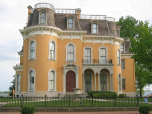 Go southwest on Market Street then turn right on Penn Street. Turn left onto East 10th Street/Old Indiana 62. Go 0.7 miles before taking the US-31ramp toward New Albany. Turn slightly right ontoUS-31. Follow the ramp toward New Albany/Browns Station Way. Merge onto Browns Station Way/Old IN62-W which becomes East Spring Street. Turn left onto Vincennes Street or Indiana 111. Turn right onto East Main Street to reach the Culbertson Mansion. Go southwest on Market Street then turn right on Penn Street. Turn left onto East 10th Street/Old Indiana 62. Go 0.7 miles before taking the US-31ramp toward New Albany. Turn slightly right ontoUS-31. Follow the ramp toward New Albany/Browns Station Way. Merge onto Browns Station Way/Old IN62-W which becomes East Spring Street. Turn left onto Vincennes Street or Indiana 111. Turn right onto East Main Street to reach the Culbertson Mansion. |
|---|---|
| Distance from Previous Site: | 7 miles / 11.2 km |
| Travel Time from Previous Site: | 15 minutes |
| Suggested Time at This Site: | 1 hour 30 minutes |
Get your first taste of New Albany with this Victorian mansion William Culbertson built in 1867. As you explore his home, you’ll discover his prosperous history, which began when he settled in New Albany at the age of 21. The young Culbertson found employment as a clerk in a dry goods store. He possessed exceptional business sense and energy, and by 1860, he had become a prosperous, independent businessman. In 1868, Culbertson retired from the dry goods business to invest his money in new ventures, including managing stock in the Kentucky-Indiana Railroad Bridge Company and establishing his own utility in 1854. He was known as a philanthropist and at his death in 1892, he had achieved a net worth of 3.5 million dollars (approximately $61 million in today’s economy). Culbertson’s story fits into Indiana’s Historic Pathways because of his tie to the early railroads and transportation industry as well as the unique architecture and beauty of his historic home, which is just off the byway.
Stop 4: Pioneer Mothers Memorial Forest
| Directions from Previous Site: | 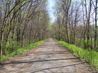 From Culbertson Mansion go southwest on East Main then right on State Street. Turn left onto West Spring Street. Merge onto I-64/US-150. Within 3.7miles, US-150 veers off and heads north. Follow this well-signed route toward Paoli, 55 miles from New Albany, and you’ll pass through the Pioneer Mothers Forest on the way. From Culbertson Mansion go southwest on East Main then right on State Street. Turn left onto West Spring Street. Merge onto I-64/US-150. Within 3.7miles, US-150 veers off and heads north. Follow this well-signed route toward Paoli, 55 miles from New Albany, and you’ll pass through the Pioneer Mothers Forest on the way. |
|---|---|
| Distance from Previous Site: | 45 miles / 72.0 km |
| Travel Time from Previous Site: | 1 hour |
| Suggested Time at This Site: | 1 hour |
Enjoy a quick stop to stretch your legs and hike a ways into the 88-acre tract of forest, the last old-growth stand of its size in Indiana. The ancient trees have been essentially undisturbed through time, so when you glance upon the woodsy landscape, it will appear much as it did to early pioneers who came through this area so many years ago.
Stop 5: Paoli Historic District and Court House in Paoli, IN
| Directions from Previous Site: | 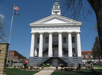 Follow the byway (US 150) into town and around the courthouse. Instead of following US 150west toward Shoals, continue around the courthouse and turn south on Gospel Street. Drive across the iron bridge, which is just one block off the courthouse square. You can then turn around, drive back across the bridge, around the courthouse square again, and get back on US 150. Follow the byway (US 150) into town and around the courthouse. Instead of following US 150west toward Shoals, continue around the courthouse and turn south on Gospel Street. Drive across the iron bridge, which is just one block off the courthouse square. You can then turn around, drive back across the bridge, around the courthouse square again, and get back on US 150. |
|---|---|
| Distance from Previous Site: | 2 miles / 3.2 km |
| Travel Time from Previous Site: | 5 minutes |
| Suggested Time at This Site: | 10 minutes |
A drive through Paoli will be the next byway experience on your agenda. The town seems to have been lost in time, preserving some of the best of its turn-of-the-century features. Follow the byway as it winds around the town and even circles the courthouse square. The court house, circa 1850, is one of the finest examples of Greek Revival architecture east of the Mississippi River and is the second-oldest operating courthouse in Indiana. Just south of the square, take a slight detour (one block off the byway) on South Gospel Street to see one of the few existing examples of the Cleveland Pratt Iron Bridges.
As you cruise around the town, also notice the murals and interesting architecture. Paoli was settled by Quakers and you’ll discover through the Quaker meeting houses along the way that this denomination still plays an important role in the community.
Overnight Point: French Lick Springs and West Baden Springs hotels, French Lick and West Baden Springs, IN
| Directions from Previous Site: | 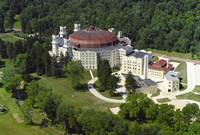 Continue on US 150 out of Paoli. At the junction of US 150 and SR 56, turn left and go about a mile into the town of West Baden. The West Badenand French Lick communities are adjacent to each other. Both hotels are on the main street and are very easy to find. Continue on US 150 out of Paoli. At the junction of US 150 and SR 56, turn left and go about a mile into the town of West Baden. The West Badenand French Lick communities are adjacent to each other. Both hotels are on the main street and are very easy to find. |
|---|---|
| Distance from Previous Site: | 12 miles / 19.2 km |
| Travel Time from Previous Site: | 17 minutes |
Although French Lick and West Baden Springs require a short jog off the byway, these two adjacent communities are well worth the detour. Stay overnight at one of the historical hotels, and learn something of their past while you’re at it.
Settled more than 200 years ago by French traders, the towns are known for their rich mineral springs where animals flocked to lick the waters and wet rocks. In 1901, a syndicate known as the French Lick Springs Hotel Co., headed by the then-mayor of Indianapolis, Irish immigrant Thomas Taggart, purchased a hotel and rocketed the area to international prominence. A railroad spur ran daily trains between Chicago and the front entrance of the hotel. People came for the curative baths and to gamble, and the “Pluto Water” (the sulphuric water common in the area’s springs) was bottled for national distribution.
The West Baden hotel, just a few miles north of the French Lick Hotel, was built in 1902 and is an incredible architectural marvel. This hotel has thrived over time as a resort and gambling facility, a hospital, a Jesuit college, and it has spent many years abandoned. Today, the hotel is fully restored and grander than ever!
Total Distance Traveled in Day 1: 71 miles / 113.6 km
Day 2
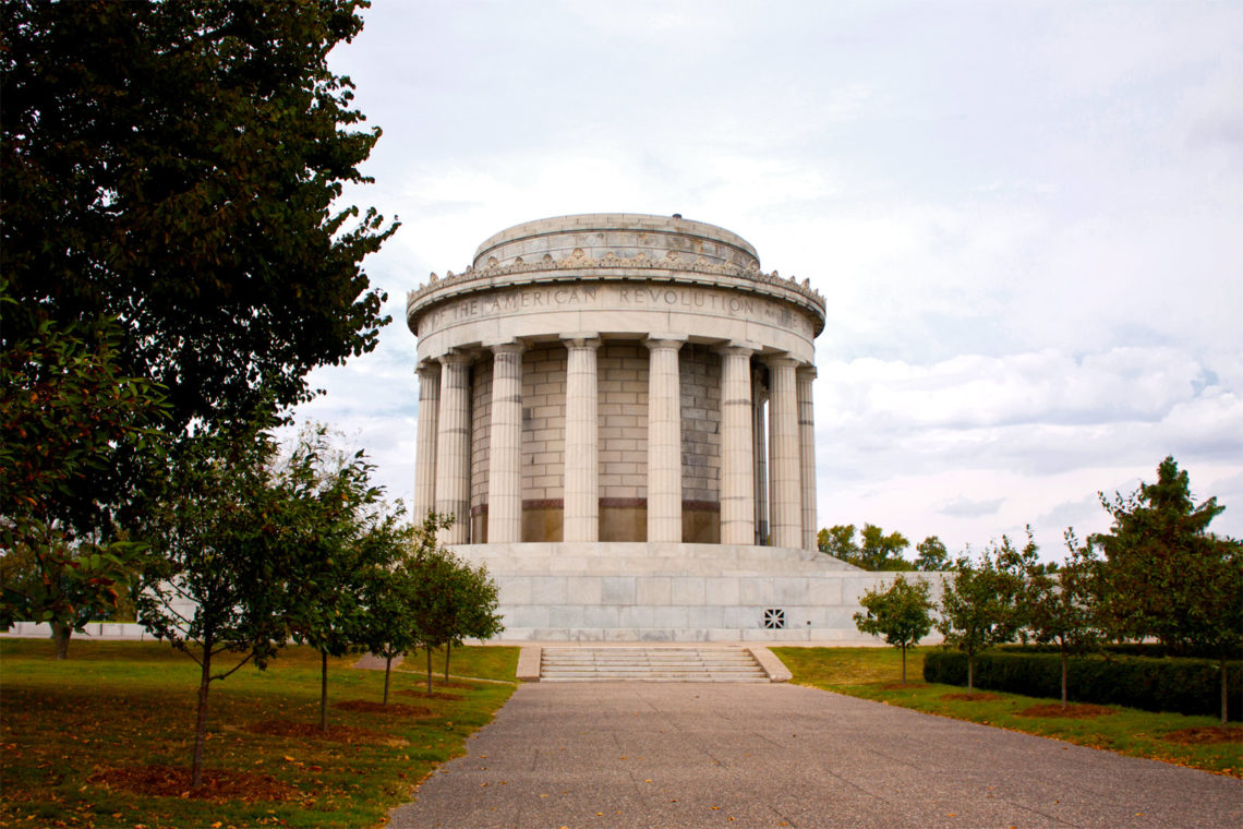
Stop 1: George Rogers Clark National Historical Park, Vincennes, IN
| Directions from Previous Site: | 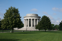 From the byway, take the US 41 exit in Vincennes. Follow the signs to George Rogers Clark National Historical Park. It is approximately one mile off the highway in downtown Vincennes, and it is located at 401 South 2nd St. From the byway, take the US 41 exit in Vincennes. Follow the signs to George Rogers Clark National Historical Park. It is approximately one mile off the highway in downtown Vincennes, and it is located at 401 South 2nd St. |
|---|---|
| Distance from Previous Site: | 60 miles / 96.0 km |
| Travel Time from Previous Site: | 1 hour 30 minutes |
| Suggested Time at This Site: | 1 hour |
Commemorate the conquest of the Northwest Territory at this national park site, the largest memorial outside of Washington D.C. Learn the significance of the early fort here and why early travelers made the historic journey over much of the same path you just made- from Clarksville to Vincennes.
Look to the interpretive center for an excellent movie and several displays that explain the history of the area.
Stop 2: Grouseland, Vincennes, IN
| Directions from Previous Site: | 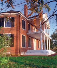 Take 2nd Street northeast. It will become Patrick Henry Drive. Turn right onto South 1stStreet and proceed 0.5 mile. Turn left onto East Scott Street. Take 2nd Street northeast. It will become Patrick Henry Drive. Turn right onto South 1stStreet and proceed 0.5 mile. Turn left onto East Scott Street. |
|---|---|
| Distance from Previous Site: | 1 miles / 1.6 km |
| Travel Time from Previous Site: | 3 minutes |
| Suggested Time at This Site: | 1 hour 30 minutes |
Visit Grouseland, the elegant Georgian home built in 1803 by William Henry Harrison when he was governor of the Indiana Territory. A National Historic Landmark, the house was more than a residence; this magnificent building was the center of government for the Indiana Territory and also served as a fortress in times of unrest. Harrison was elected ninth president of the United States in 1840, so the home is a presidential site with exhibits that contain colorful campaign memorabilia.
End: Vincennes State Historic Site
| Directions from Previous Site: | The Vincennes State Historic Site is adjacent to Grouseland. |
|---|---|
| Travel Time from Previous Site: | 1 minute |
 Come to Vincennes State Historic site and you’ll stand at the same place Tecumseh once stopped, where troops mustered courage for the battle of Tippecanoe, where laws were passed that still affect Indiana residents today, and where the first free press in Indiana was born.
In 1805, when the territory’s population reached 5,000 free men and the territory moved to the second stage of government, the people elected a nine-member House of Representatives. in 1811, the legislature, called the General Assembly, moved into the building simply called the “Red House,” which you can still visit today.
Drive by, or pull over and walk past the “Red House” and the many historic buildings nearby. Immediately next to the “Red House,” check out the Elihu Stout Print shop, which started printing weekly newspapers in 1804, or admire the architecture of the Old State Bank to wrap up your byway experience.
Total Distance Traveled in Day 2: 61 miles /97.6 km