
Maps
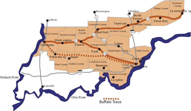
Download a PDF of the Indiana’s Historic Pathways Map
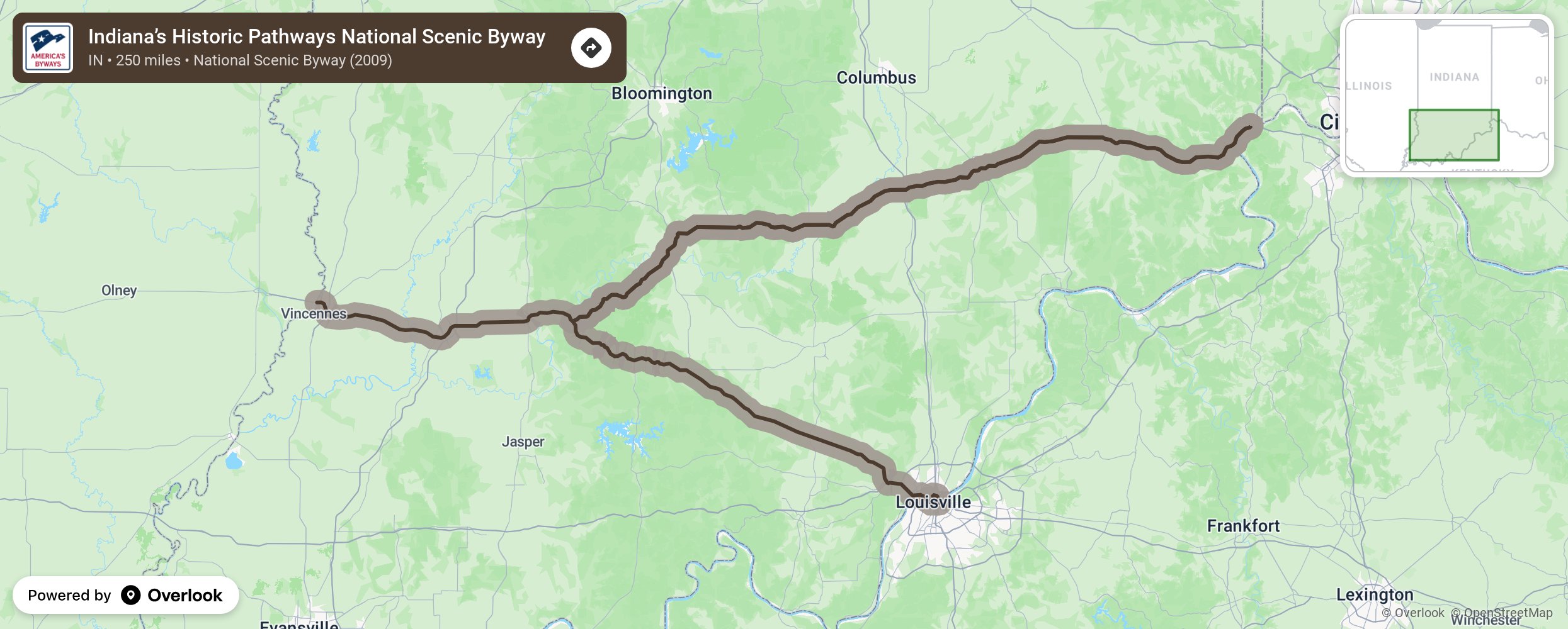
The Byway comprises the following segments:
1. U. S. 50 (overlaps U.S. 150 to Shoals)
| SEGMENT | MILEAGE | CLASSIFICATION |
|---|---|---|
| Vincennes: | ||
| 2nd Street to Vigo Street | .3 | city/urban |
| Vigo Street to 7th Street | .3 | city/urban |
| 7th St. (Washington Ave.) to Old Highway 50 | 2.4 | city/urban |
| Old Highway 50 to New US Highway 50 | 10.8 | secondary/rural |
| Highway 50 to Maysville Road | 10.8 | primary/rural |
| Washington: | ||
| Maysville Rd. to Old Highway 50 | .2 | secondary/rural |
| Old Highway 50 to New US Highway 50 | 5.3 | city/urban |
| US Highway 50 to US Highway 50/37 | 39.6 | secondary/rural |
| Bedford: | ||
| US Highway 50/37 to Old Highway 50 | 1.3 | primary/rural |
| Old Highway 50 to US Highway 50 (16th St.)(west bound) H Street-to15th Street
15th Street to M Street M Street to Old US 50 |
1.1 (east bound) | primary/ urban |
| US Highway 50 (16th St.) to US Highway 50 | 1.9 | secondary/urban |
| US Highway 50 Bedford to Brownstown | 27.2 | secondary/rural |
| US Highway 50 Brownstown | 1.8 | secondary/urban |
| US Highway 50 Brownstown to Seymour | 7.5 | secondary/rural |
| US Highway 50 Seymour | 4.8 | secondary/urban |
| US Highway 50 Seymour to North Vernon | 10.9 | secondary/rural |
| US Highway 50 North Vernon | 2.5 | secondary/urban |
| US Highway 50 to Junction St. Hwy. 101 | 26.8 | secondary/rural |
| US Highway 50, Junction SR 101 to Aurora | 12.6 | primary/rural |
| US Highway 50 Aurora to Ohio State Line | 13.0 | primary/urban |
| TOTAL MILEAGE U.S. HIGHWAY 50—–181.1 |
2. HIGHWAY 150 (overlaps U. S. 50 to Shoals)
| SEGMENT | MILEAGE | CLASSIFICATION |
|---|---|---|
| Vincennes: | ||
| 2nd Street to Vigo Street | .3 | city/urban |
| Vigo Street to 7th Street | .3 | city/urban |
| 7th Street (Washington Ave.) to old Highway 150 | 2.4 | city/urban |
| Old Highway 50/150 to New US Highway 150/50 | 10.8 | secondary/rural |
| New US 150/50 to Maysville Road | 10.8 | primary |
| Washington: | ||
| Maysville Road to Old Highway 150/50 | .2 | secondary/rural |
| Old Highway 150/50 to US Highway 150/50 | 5.3 | city/urban |
| US Highway 50/150 to US Highway 150 (Shoals) | 19.9 | secondary/rural |
| US Highway 150 (Shoals) to Paoli Pike | 57.2 | secondary/rural |
| New Albany/Clarksville: | ||
| Paoli Pike (State St.) to Main St. | 5.9 | secondary/urban |
| Main Street (east bound to Hwy.62) to Randolph Ave | 3.8 | secondary/urban |
| **Highway 62 to Spring St. (one way west bound) | secondary/urban | |
| Randolph Ave. to Harrison Ave. | .4 | secondary/urban |
| Harrison Ave. to South Clark St. | .1 | secondary/urban |
| South Clark St. to Sherwood Ave. | .9 | secondary/urban |
| Sherwood Ave. to Riverside Drive | .5 | secondary/urban |
| Riverside Drive to Falls of Ohio parking lot | .3 | secondary/urban |
| TOTAL MILEAGE US HIGHWAY 150—–119.1 |
TOTAL MILEAGE, INDIANA’S HISTORIC PATHWAYS: 250.2 (50 miles of U.S. 50 and 150 overlap, Vincennes to Shoals; extant segments of the Buffalo Trace on primary and secondary roadways are included in the entries in Parts 1 and 2 above.)
BUFFALO TRACE LOOP
| SEGMENT | MILEAGE | CLASSIFICATION |
|---|---|---|
| Vincennes: | ||
| 2nd St. Vigo St. | .3 | city/urban |
| Vigo Street to 7th Street | .3 | city/urban |
| 7th Street to Hart Street | .4 | city/urban |
| Hart Street to Holman Road | 12.4 | secondary/rural |
| Holman Road to Campbell Road | .6 | rural/gravel |
| Campbell Road to Beech Hills Road | .9 | rural/gravel |
| Beech Hills Road to Jones Road | 3.4 | rural/gravel |
| Jones Road to State Highway 61 | .5 | rural/gravel |
| State Highway 61 to River Road | .9 | rural/gravel |
| River Road to County Road 250W | 1.4 | rural/gravel/paved |
| County Road 250W to State Highway 56 | 2.3 | rural/paved |
| State Highway 56 to State Highway 356 | 1.7 | secondary |
| State Highway 356 to State Highway 257 | 9.1 | secondary |
| State Highway 257 to County Road 325N | 3.8 | secondary |
| County Road 325N to County Road 1100E | 1.9 | rural/chip+seal |
| County Road 1100E to County Road 560N | .7 | rural/gravel |
| County Road 560N to County Road 800W | 1.1 | rural/gravel |
| County Road 800W to County Road 580N | .2 | secondary |
| County Road 580N to County Road 550W | 2.5 | secondary |
| County Road 550W to County Road 600N | .1 | secondary |
| County Road 600N to County Road 500W | .5 | secondary |
| County Road 500W to County Road 570N | .2 | secondary |
| County Road 570N to County Road 400W | 1.0 | secondary |
| County Road 400W to County Road 500N | .8 | rural/chip+seal |
| County Road 500N to Portersville Road | 1.1 | secondary |
| Portersville Road to County Road 600N | .7 | secondary |
| County Road 600N to Old St. Route 45 | 2.2 | rural/gravel |
| Old St. Route 45 to US Highway 231 | .6 | secondary |
| US Highway 231 to State Highway 56 | .6 | secondary |
| State Highway 56 to Cuzco Road | 9.3 | secondary |
| Cuzco Road to Main St. (Cuzco) | 2.5 | rural/gravel |
| Main St. to Cuzco Road | .1 | secondary |
| Cuzco Road to Cuzco-Norton Road | .8 | secondary |
| Cuzco-Norton Road to County Road 750N | 1.7 | rural/chip+seal |
| County Road 750N to County Road 375S | 2.5 | rural/chip+seal |
| County Road 375S to State Highway 145 | 2.2 | rural/paved |
| State Highway 145 to County Road 410S | .9 | secondary |
| County Road 410S to County Road 575S | 3.6 | rural/paved |
| County Road 575S to County Road 475W | 2.0 | rural/paved |
| County Road 475W to County Road 510S | 2.4 | rural/paved |
| County Road 510S to State Highway 37 | 3.8 | rural/paved |
| State Highway 37 to Valeene Road | 1.4 | secondary |
| Valeene Road to County Road 820S | 5.4 | rural/paved |
| County Road 820S to County Road 575E | 2.8 | rural/paved |
| County Road 575E to County Road 925S | 2.2 | rural/paved |
| County Road 925S to County Road 675E | 1.8 | rural/chip+seal |
| County Road 675E to County Rd 50E | .7 | rural/paved |
| County Road 750E to State Highway 66 | 3.7 | rural/gravel |
| State Highway 66 to Totten Ford Road | .8 | secondary |
| Totten Ford Road to North Road | 5.4 | rural/paved |
| North Road to Hancock Chapel Road | .1 | rural/paved |
| Hancock Chapel Road to Greenville Rd | 10.4 | rural/paved |
| Greenville Road to US Highway 150 | .5 | secondary |
| US Highway 150 to Buttontown Road | .4 | secondary |
| Buttontown Road to Old Vincennes Rd | 1.3 | secondary |
| Old Vincennes Road to Luther Road | 8.1 | secondary |
| Luther Road to Old Route 150 | 2.1 | secondary |
| New Albany/Clarksville: | ||
| Old Route 150 to Main St. (New Albany) | .8 | secondary/urban |
| Main St. to State Highway 111 | 1.1 | city/urban |
| State Highway 111 to Spring Street | .2 | city/urban |
| Spring Street to Emory Crossing Road | 1.3 | city/urban |
| Emory Crossing Road to Clark Cabin | 1.4 | city/urban |
| TOTAL MILEAGE BUFFALO TRACE—–142.6 | ||
| SIDE TRIP (New Albany/Clarksville) | ||
| McCullock Pike to State Highway 131 | .5 | city/urban |
| State Highway 131 Gutford Road | .4 | city/urban |
| Gutford Road to Silver Creek Crossing | .8 | city/urban |